In Baltimore, heavy rain is often accompanied by sewage overflows into the city’s waterways.
The figures often released in the days afterward, with the number of gallons of the toxic mix of wastewater and rainwater – sometimes in the millions – and the location where the overflow happened.
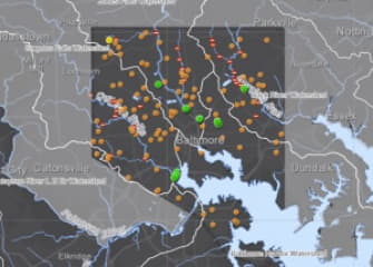
The Baltimore Department of Public Works is offering a way to speed up the notification process and track the sewage by map.
An interactive map debuting on the DPW’s website Friday provides a look at where the overflows are occurring using “near real-time” data. All known overflows are shown, and it’s available on the map for four months.
READ FULL ARTICLE HERE

